


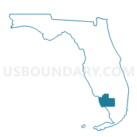
502-Voting District, Collier County, Florida
About
Outline

Summary
| Unique Area Identifier | 552531 |
| Name | 502-Voting District |
| County | Collier County |
| State | Florida |
| Area (square miles) | 825.23 |
| Land Area (square miles) | 823.50 |
| Water Area (square miles) | 1.73 |
| % of Land Area | 99.79 |
| % of Water Area | 0.21 |
| Latitude of the Internal Point | 25.94690980 |
| Longtitude of the Internal Point | -81.09608180 |
Maps


Graphs
Select a template below for downloading or customizing gragh for 502-Voting District, Collier County, Florida


Neighbors
Neighoring Voting District (by Name) Neighboring Voting District on the Map
- 32-Voting District, Monroe County, FL
- 454.6-Voting District, Miami-Dade County, FL
- 454.7-Voting District, Miami-Dade County, FL
- 501A-Voting District, Collier County, FL
- 594-Voting District, Collier County, FL
- EVERGL-Voting District, Broward County, FL
- Evrgld-Voting District, Collier County, FL
- GOM-Voting District, Collier County, FL
- Portof-Voting District, Collier County, FL
Top 10 Neighboring County Subdivision (by Population) Neighboring County Subdivision on the Map
- Immokalee CCD, Collier County, FL (50,294)
- Everglades CCD, Collier County, FL (15,084)
- Everglades CCD, Miami-Dade County, FL (6,578)
- Cape Sable CCD, Monroe County, FL (24)
- Conservation CCD, Broward County, FL (20)
Top 10 Neighboring Unified School District (by Population) Neighboring Unified School District on the Map
- Dade County School District, FL (2,496,435)
- Broward County School District, FL (1,748,066)
- Collier County School District, FL (321,520)
- Monroe County School District, FL (73,090)
Top 10 Neighboring State Legislative District Lower Chamber (by Population) Neighboring State Legislative District Lower Chamber on the Map
- State House District 112, FL (210,556)
- State House District 101, FL (189,600)
- State House District 120, FL (170,078)
- State House District 76, FL (149,992)
Top 10 Neighboring State Legislative District Upper Chamber (by Population) Neighboring State Legislative District Upper Chamber on the Map
Top 10 Neighboring 111th Congressional District (by Population) Neighboring 111th Congressional District on the Map
Top 10 Neighboring Census Tract (by Population) Neighboring Census Tract on the Map
- Census Tract 112.02, Collier County, FL (18,805)
- Census Tract 111.02, Collier County, FL (7,291)
- Census Tract 115, Miami-Dade County, FL (6,578)
- Census Tract 9800, Monroe County, FL (24)
- Census Tract 9800, Broward County, FL (20)